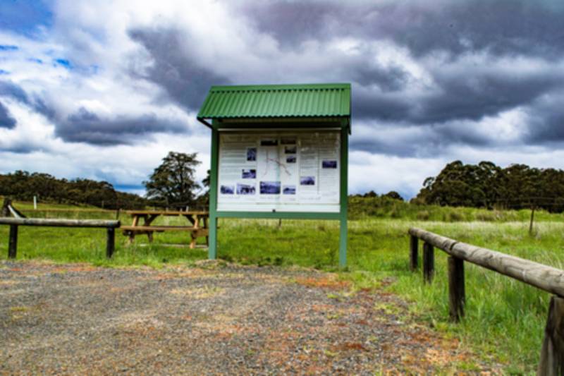
This informative roadside stop features a picnic table and a large information sign, providing history, recollections and images of the Italian Gully historic township.
When coming from Scarsdale/Ballarat side, this wayside stop is located right on the corner when you turn onto Jubilee Road to head towards the Jubilee Historic Area.
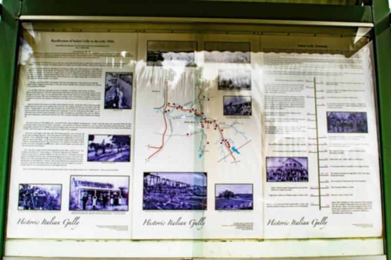
The Italian Gully information sign is beautifully presented and displays historical photographs, a map of the area, and the following text:
ITALIAN GULLY TOWNSHIP
Prior to the discovery of gold John Brown's station "Moppianum" included the area later known as Italian Gully.
In 1852 a man named Bundye found gold at this location while prospecting during a trip from Geelong to Pitfield.
In 1855 a party of Italian miners struck gold in this gully and the area became known as Italian Gully.
In 1856 a Census shows that 324 people lived in Italian Gully, 220 males and 104 females.
By 1863 alluvial mining was on the wane. People left the area to pursue more promising finds elsewhere. Mining surveyor John Lynch reported that the biggest problem facing mining in the Italian Gully area was the lack or excess of water.
Mining was not the only industry in the area. There was a saw milling business, several carriers, hotels and a range of shops.
In 1860 the Church of England opened a school which closed in 1865. From this time until 1904 when a government school was provided children attended the Scarsdale or Piggoreet schools. The government school closed in 1934 due to low attendance.
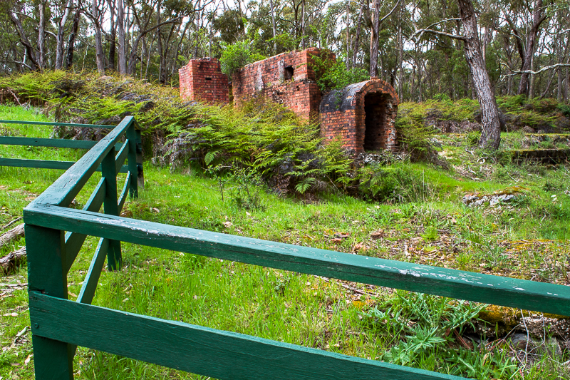
Mining remained at a low ebb until 1887 when the Greenwood Brothers and their brother in law Mr Richards discovered the Jubilee reef about 2kms south of Italian Gully.
From 1887 through until 1913 when it closed the
Jubilee Mine supported a large community which was serviced by many businesses including grocers, bakers, butchers, hotels, blacksmiths and more.
After the first World War in 1923 a Government Battery (quartz crushing plant) was set up just south of the Italian Gully township to encourage quartz reef prospecting in the hope that another Jubilee reef might be found. Sadly this was not to be and the Battery was closed in 1947.
- 1844 John Browne's Moppianum run is established
- 1852 Gold is discovered in Victoria and at the location later called Italian Gully
- 1855 A party of Italian miners strike gold near where John Boyds Blacksmith shop later stood and at the junction of two gullies. The name Italian sticks and the main gully becomes Italian Gully. The side gully is now known as Splitters Gully the origin of this name is not known.
- 1857 A cencus at Italian Gully diggings shows a population of 324. Males 220. Femails 104.
- 1859 Mining Surveyor's report says 40 claims registered on the Black Ball deep lead with 6 or 7 working. Three puddling machines working and a population of around 700. A Methodist Church is erected 20' x 16', construction is of a canvas roof and walls witha dirt floor and hardwood seats. John Pounder Roberts builds a general store well stocked with groceries, ironmongery, boots, shoes and mens drapery.
- 1860 A new Methodist Church is built at Italian Gully.
- 1861 A census shows a population of 926. Males 621. Females 305. Chinese 49. Dwellings 321. Coaches from Ballarat and return running 3 times per day.
- 1862 An Aboriginal tribe visits Italian Gully looking for water causing some alarm to residents.
- 1863 Mining at Italian Gully is in decline and with many large mines working at other locations many residents have left.
- 1865 Dr Lewis Saenger shot and killed at Italian Gully. The road from Smythesdale through Browns and Monkey Gully surveyed and cleared. Many small parties working on alluvial but the bulk of the population has left.
- 1870 Many small alluvial mines in operation, only 150 miners remaining, only bush roads and no conveyances.
- 1882 Only 10 miners now in Italian Gully.
- 1887 The Jubilee reef is discovered by the Greenwood Brothers and also their Brother in law, Mr Richards.
- 1887 - 98 The successful Jubilee mine gives Italian Gully a new life.
- 1898 The Jubilee mine is sold to the Jubilee company and the operation is expanded.
- 1904 A Government school is provided for Italian Gully.
- 1913 Jubilee mine closes. Italian Gully is in decline again.
- 1923 A Government Battery is provided to encourage prospecting.
- 1930 - 1940 The road from Newtown through Italian Gully to Berringa is formed and surfaced.
- 1934 The Government School closes due to low attendences.
- 1947 The Government Battery is closed.
- 1950 - 1970 Italian Gully has largely disappeared but the road from Newtown is rebuilt and sealed.
- 1960 Electricity comes to Italian Gully.
- 1964 A light plane crashes just off Splitters gully at Italian Gully.
- 1970 Browns road is constructed from Smythesdale to Italian Gully and later sealed providing a more direct route to Smythesdale.
- 2014 Italian Gully township is no more, the area is used for grazing with only a handful of descendents from the original familys still in the area. Many of the mine workings have been leveled and the quartz tailings removed for roadmaking, traffic on the sealed road is substantial due to residential subdivisions at Staffordshire Reef and Berringa.
RECOLLECTIONS OF ITALIAN GULLY IN THE EARLY 1900s
People who lived between W to W corner at Newtown, and Staffordshire Reef
Part 1 Italian Gully
by Harold Frazer, 1910 - 1989.
Harold was born and grew up at the Reef, and worked mostly locally until the late 1930s. This recollection was hand-written by him in about the early 1980s. References to 'now' or the present are obviously out of date by many years. The transcription is pretty much word-for-word except for some adjustments to punctuation, sentence structure, and expanded abbreviations.
At Newtown's W to W Corner, on your left as you turned onto the Reef road, was erected the sign board of W. F. Coltman, Timber Merchants of Ballarat. On the right of the road, standing almost out of sight, was the family of Griffin, related to the Callaghans of Berringa and Cape Clear.
At the foot of the hill was the old bridge over the Monkey Gully creek. A little further on, on the right, was old John Crosthwaite and on the left was Crosthwaite's Store, sold much later to Sid Powney - where I worked for a much appreciated £2 a week for a couple of years or so in the Depression years. Sid later marriend Florence Luck, a school teacher who previoiusly fostered two boys, Gordon and Albert. After Sid died she adopted another boy and named him Keith Rodney Powney after her brother who was a high-ranking officer in the British Navy. Next door was Alf Crosthwaite, a son of John.
The next road on the left led to the Monkey Gully dam and redfin, also to the strawberry and vegetable gardens of Glen Shepherd and his father. In the same area was old Bill Cook, and about seventeen cats. Bill was a very good haystack builder.
On the right of the main road again was Isaac Crosthwaite, son of John, and his family of Graham (still working strawberries in 1979), his sisters Dorothy and Heather, and at least one more brother, Hector. On the left opposite was Bill Carey, his wife and Ruth, Keith, Tom and Jack. Ruth later married Glen Shepherd and is now living in Scarsdale. Bill Carey owned land all over the place and in the Depression succeeded as owner of two cyanide plants, one below our old place at the Reef and the other at the junction of Long Gully and the Speedwell Gully.
Again on the left of the road was the Italian Gully Methodist Church, not far from where Colin Armstrong's holiday home now stands; on the opposite side of the road and standing well back was the Italian Gully State School, Lowdens bakery was on the corner of School Lane. A little further on, on the left and at the bend in the road, was another road or bush track to Browns near Smythesdale. At the foot of the hill was the bridge over the creek which rises at the Reef, and immediately on the right a road leads up to the Jubilee mine, close on 2100 feet deep, with its big battery and the sand which has been twice cyanided and finally trucked to Ballarat for building use.
But back to the start of this Jubilee road - on the left of this road was Weekes' boarding house, a hotel, and other places; next up toward where the Government Battery stood was Geo Head and family - a son Jack lives in Newtown. Further on, over in the bush, were people named Greenwood. Further along Jubilee road were the New Jubilee and the East Jubilee mines, but they were not the size of the main Jubilee. Just below the East Jubilee dam old Maurice O'Keefe had his hut and we used to walk there from the Reef to buy vegetables.
Back now to the bridge on the main road. The Armstrong home was on the left and on the right was Bishop's big store, and a few hundred yards further was a small mine, the Cambrian. Next is Hollyoake's bridge with their home just a little further on. Next on the right was Duncan McGregor's; on the same site much later someone sunk a shaft and had a whip on it for pulling up the dirt. Not much success as far as gold was concerned. A little further on the left were people named Morrow, and over on the right on the other side of the creek were the Dwyer family.
Then came the crossing at the foot of the long hill, just where cousin Vic Guy has his house, with Alan Guy a little further on. On the left originally were the Boyds, relatives of Aunty Amy (i.e. mother of Wally, Vic, Alan, Les Guy, etc). They had a nice little garden orchard down near the creek - fresh peach & apples were favourites. Of course Uncle Walter, Aunty Amy and family lived for many years (where) the old Boyd home (was) just behind where Les and Helen Guy now live. They moved there after leaving the Reef where they had a wattle-and- daub house; before that they lived in the old original Guy home at the Reef which in my time housed Aunty Em and Hughie McLeod.
Next on the left after the Guys, and the last houses I know of there, were people named Curry and Robinson - then on towards the Reef.
SEE ALSO