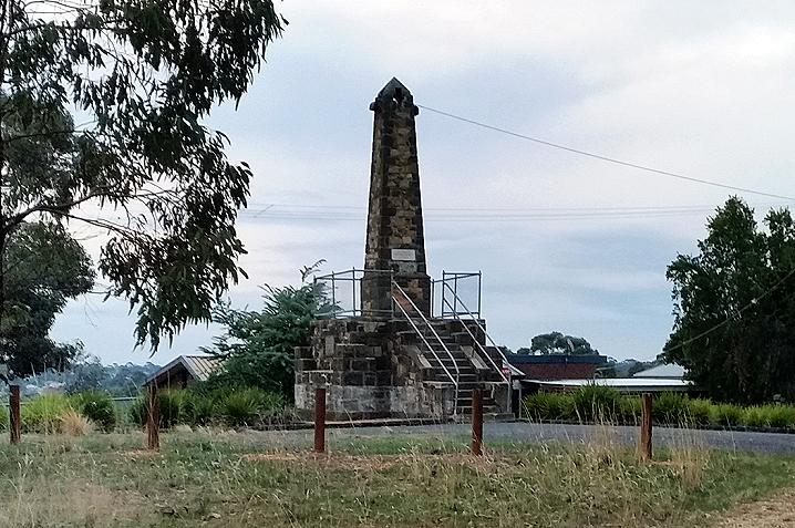
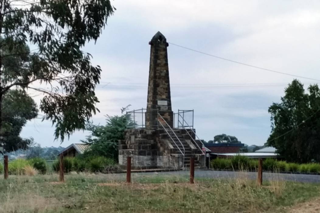
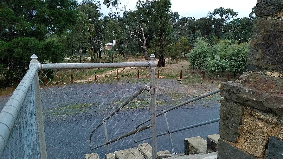
Atop a hill on Kennedy Street, Maryborough lies the Simson Brothers Memorial Lookout.
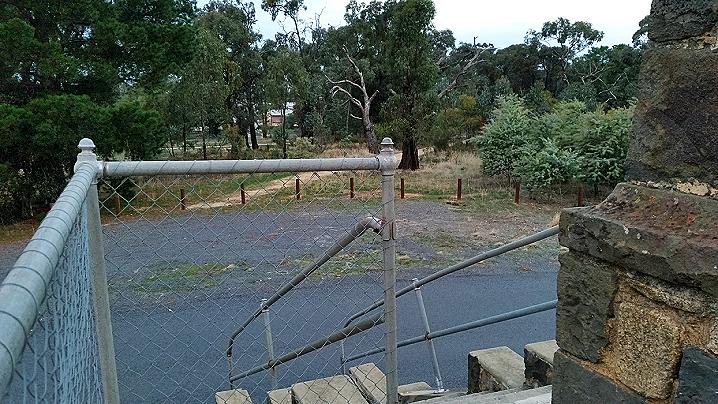
The lookout offers good views over the town and is alongside
Roscholler Park, which features a playground, basketball and netball hoops, football goals and picnic tables.
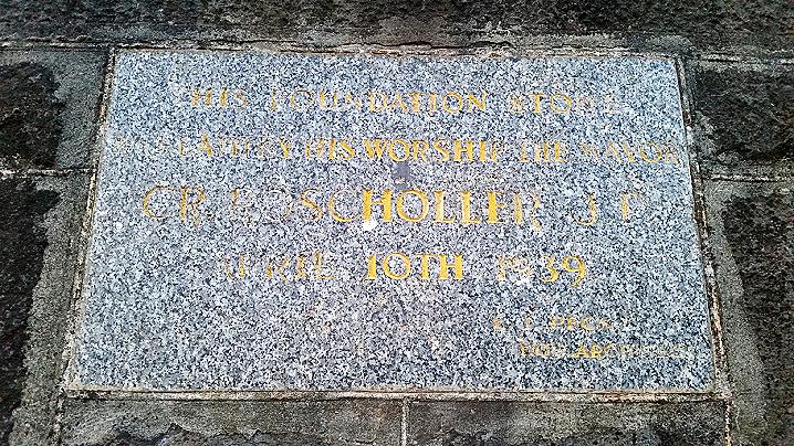
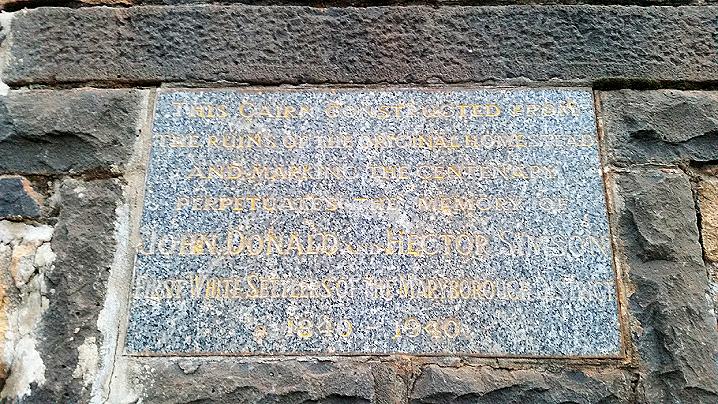
The inscriptions on the memorial say:
This cairn constructed from the ruins of the original homestead, and marking the centenary, perpetuates the memory of John, Donald and Hector Simson, first white settlers of the Maryborough District 1840-1940
and
This foundation stone was laid by His Worship the Mayor Cr. Roscholler J.P.
April 10th 1939
E. J. Peck Hon. Architect
The following text was printed in The Argus, a Melbourne Newspaper, in 1934:
Source: http://trove.nla.gov.au/newspaper/article/10921466
A Great Pioneering Family
x this textTHE SIMSONS
By STANLEY MOORE
One of the most important of our early
pioneering families was that of the Simsons, of Charlotte Plains Station, near
the site of the modern Maryborough (V.). As station-owners and flockmasters their activities extended over two generations, from 1840 to 1879. The stretch of country originally opened up by them reached to Laanecoorie on the north, to the Pyrenees on the west, to Castlemaine on the cast, and to Clunes on the south. They were associated with the White Hills gold rush In 1854, but, by their silence in regard to a nugget found there, prevented a rush to Daisy Hill In 1848, years before the official discovery of gold in Victoria.
In 1839 Donald and Hector Simson sailed from Islay, on the West Coast of Scotland, for Australia, where they arrived in November of that year. Their first intention was to settle in the Portland district. They collected 13,000 sheep and 4,000 cattle at Maneroo, in New South Wales, ready for the journey overland to Portland. This was one of the largest flocks that had come overland up till that time.
Prices were high. It is said that a ewe cost £2, cattle sold from £10 to £15, and horses brought £100. The stock were started on their overland route in charge of Darlot and Jones, employees of the Simsons. Donald Simson sailed round to Melbourne, and travelling north met the stock coming overland at Mt. Alexander. But, as the ewes had begun to lamb, he decided not to continue the journey, but to take up land on the Deep Creek and the Loddon. The great sweep of country he was the the first to occupy was later divided into the stations known as Charlotte Plains, Cairn Curran, Janevale, and Glenmona, Maryborough, Carisbrook, Bet Bet, Laanecoorie, and other towns now stand on the area covered by these stations. After a time their elder brother John joined Hector and Donald from Scotland, and they sold Cairn Curran, Glenmona, and Janevale stations. On the Green Hill, near the Deep Creek, they made the foundations for a house, and excavated a cellar. At this stage a favourite horse, Noble, broke his neck in the collar, and the brothers abandoned the site as unlucky. They then built on a site lower down the hill, towards the river.
At the time it was built Simson House was one of the finest station homesteads in Australia. It was begun in 1843 and completed in 1848. It was built of stone, the first house of that material in Victoria. In the form of a quadrangle, it contained 18 rooms. The walls were nearly 2ft thick. When the great gate was closed It was impregnable to attack by the blacks, and a large underground tank in the quadrangle gave a safe water supply. The building wood used and the furniture were imported from England. The house is now an unroofed ruin with crumbling walls, but in recent times was in good preservation. The aboriginal tribe of the vicinity was friendly, and gave much assistance in sheep-washing and other station work. It was known as the Jim Crow tribe, and the name is preserved in the Jim Crow Hill, sometimes called Mount Franklin. The station sheep were divided into flocks of from 500 to 1,000 sheep, each in charge of a shepherd. At night each flock was driven into a rough yard made of fallen logs and tree branches.
Much of the wall that once formed the station sheep wash is still standing. It was built across the Deep Creek just below the spot where Hooper's bridge now stands. It was of bluestone, 130 ft. long, 6ft. wide, and of 10ft. at its greatest height. When they first settled, the Slmsons had built a bridge over the Deep Creek by the homestead. It was a common practice In those times to exact a toll from travellers wishing to cross a private bridge. This was much resented by men who made their living on the road. Sometimes ingenious tricks were used to evade the toll. One such incident became notorious. A certain bullock-driver always carried a £100 cheque which he presented in payment of the toll at all private bridges. Till he came to Simson's bridge no one had been able to cash the cheque at once, so he had been able to cross without payment. Confident in his habitual success, he presented the cheque to Donald Simson, but was greatly surprised when Donald walked to the homestead and returned with the change. The fame of the bullock driver's ruse had gone before.
Another incident in connection with the same bridge was more tragic. John Simson was a fine swimmer and a man of great strength. It is said that he would often walk into the yard, throw a bullock to the ground with his bare hands, and hold it there. One day, when the flood was over the bridge, a bullock driver attempted the crossing while John looked on from the bank. When he was half way over the bullocks lost their footing, and dray and team, with their driver, were carried into the river. In attempting to rescue the driver John Simson himself was drowned.
Donald Simson died In 1851, and his widow took her family of two sons and one daughter to Europe to be educated. The sons were John and David, and the daughter was Charlotte. John, who studied in Germany, married a German baroness. After Donald's death, Hector Simson managed the station until 1858. In that year he took up Tatong Station, ten miles from Benalla. He died there in 1880. Between 1858 and 1865 Charlotte Plains was rented by Messrs. Yuille. In 1865 John and David Simson returned and resumed control. They lived in much style at Simson House and were among the social leaders of Victoria. After a time John Simson moved to Maryborough and set up an auctioneering business on the site of the existing premises of Mr. R. Wilkinson, chemist. He once stood (unsuccessfully) for Parliament.
David Simson carried on the station, and his interest in horsebreeding improved the standard of light horses in the district. A Melbourne Cup winner is said to have been bred on the station. Lavish expenditure and certain unfortunate ventures finally wrecked the Simson fortunes, and In 1879 they relinquished the station. David Simson established a labour agency In Melbourne, at Kirk's Bazaar. He died In 1907. John Simson left Maryborough and went to Melbourne in the early 'nineties, and later he went to the goldfields in Western Australia.
The following text regarding the Simsons' involvement in the gold rush was printed in a souvenir book which marked the official opening of the Bristol Hill Memorial Tower in 1933:
In 1848, several years after the brothers Simson had established themselves on the station, which they named Simson's Range, a bullock driver in their employ, according to the late J. C. Simson, discovered a nugget of gold, on that part of the run about ten miles from the homestead, now known as Daisy Hill. He showed the gold to his employers, but they took no steps to make public the discovery. The early squatters of those days kept finds secret for fear of a rush impeding their pastoral activities. What became of the nugget is unknown, but probably it was sold to one of the Melbourne jewellers, as they were the only buyers of the precious metal before the discovery of the goldflelds.
It was not till 1851 that the first official discovery of gold in Victoria was made. Gold was found at Chines, on July 8, 1851, at Buninyong, on August 9, Castlemaine September 10, at Ballarat on September 8, and at Bendigo in 1852. Shortly after, in June, 1854, Hector Norman Simson was making a tour of the station, when he saw three young men working at a hole at a place known as the White Hills, about three miles from the homestead. He approached them, and, on inquiry, they told him they were looking for gold, but had very little luck, at the same time showing him a matchbox containing a small quantity of the metal. But from their demeanor, and the large amount of work they had done, Simson concluded they were doing better than they admitted, and had made an important discovery. They were diggers of some experience, having worked on the Castlemaine and Bendigo fields, but with little success.
One was reputed to be a young English medical man, and many of the early residents regarded him as being identical with the late Dr. F. M. Laidman, a well-known surgeon, for many years coroner for the district, who was known to have worked on the rush as a digger in 1854, and for 25 years afterwards practised his profession in Maryborough. At no time did he claim to be one of the discoverers, and the records of the Mines Department show that the names of the three first discoverers of the Simson's Range goldfield were unknown, and that no claim was made for a reward. None was paid by the Government for its discovery.
Simson lost no time in making the discovery known - a contrast to his attitude on the finding of the nugget in 1848. On the rustic log bridge over the Deep Creek near the homestead, traces of which are still visible, he erected a notice as follows: - "This way to the New Goldfleld." The news spread rapidly to the city, and other goldflelds and a great influx of diggers set in from all parts of the colony. The tracks and roads leading to Simson's Range were alive with people. Many carried swags, some with wheelbarrows, whilst coaches, waggons and vehicles of all description laden with diggers and their belongings, sped along the track. They were mostly young, unmarried men, a few foreigners, and elderly men, but even married men with their families were among the throng. All classes were represented - laborers, artisans, seafaring men, tradesmen, professional men, and others who had discarded their usual avocations in this mad rush for gold.
...
The diggers lived principally on damper and mutton, which was plentiful, and which was regularly procurable from the Simsons.
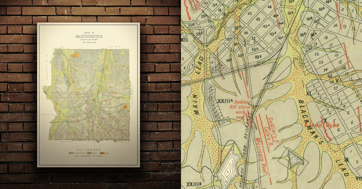
GEOLOGICAL MAP OF THE MARYBOROUGH GOLD FIELD, EARLY 20TH CENTURY
Geological map of the Maryborough gold field which shows historical features in superb detail, including reefs, leads, gullies/flats, and old workings. Originally published by the Department of Crown Lands and Survey, early 20th century. High quality, durable A1 print in a satin finish. Large, 594 x 891 mm. Go to online shop.