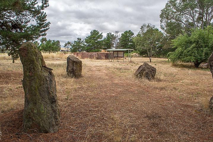
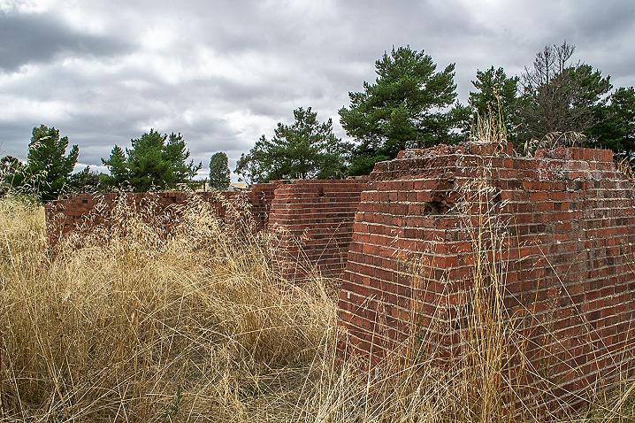
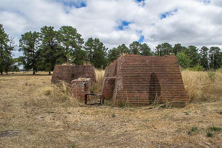
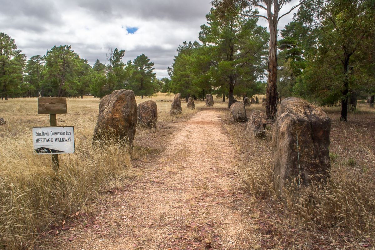
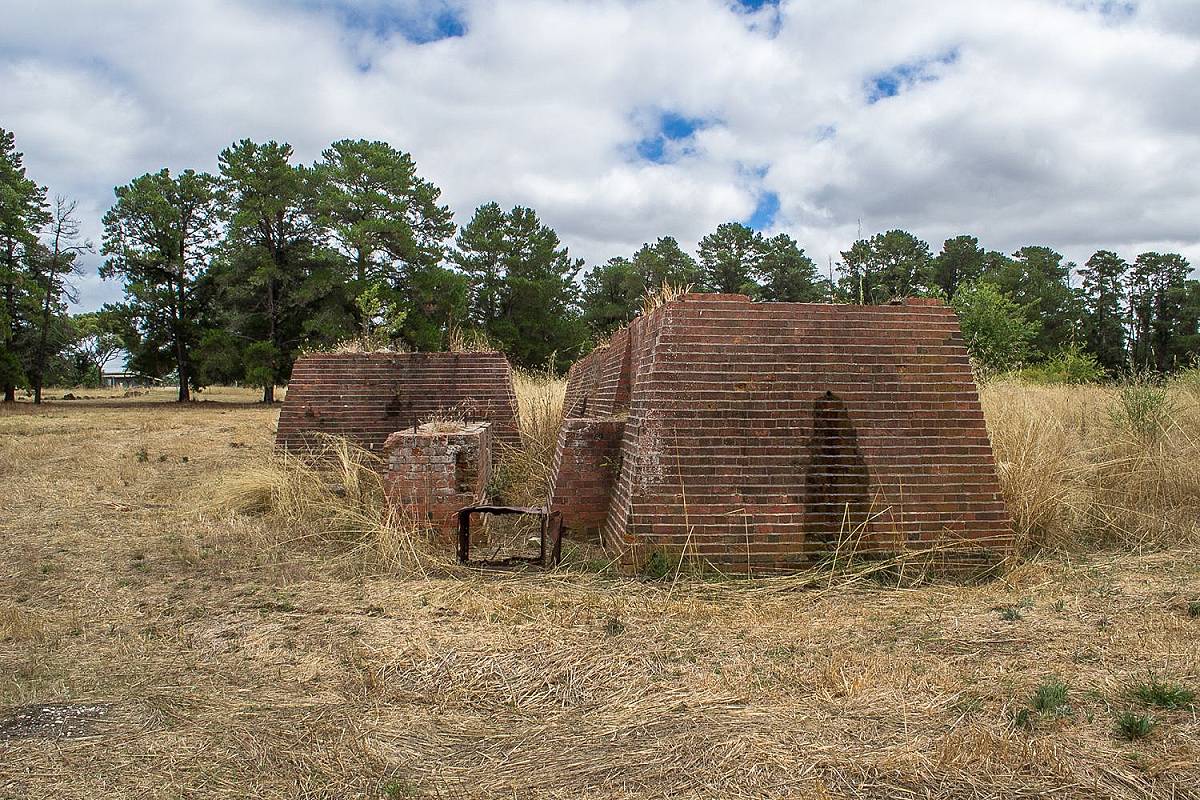
The heritage walkway begins alongside the parking area and is lined with beautiful large stones, which are great for kids who love to climb. There's a picnic table alongside the beginning of this walk. The path takes you to the large brick foundations from the Chalks No. 3 gold mine, over in the back left of the park.
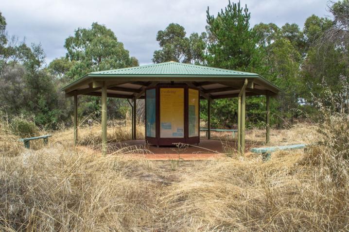
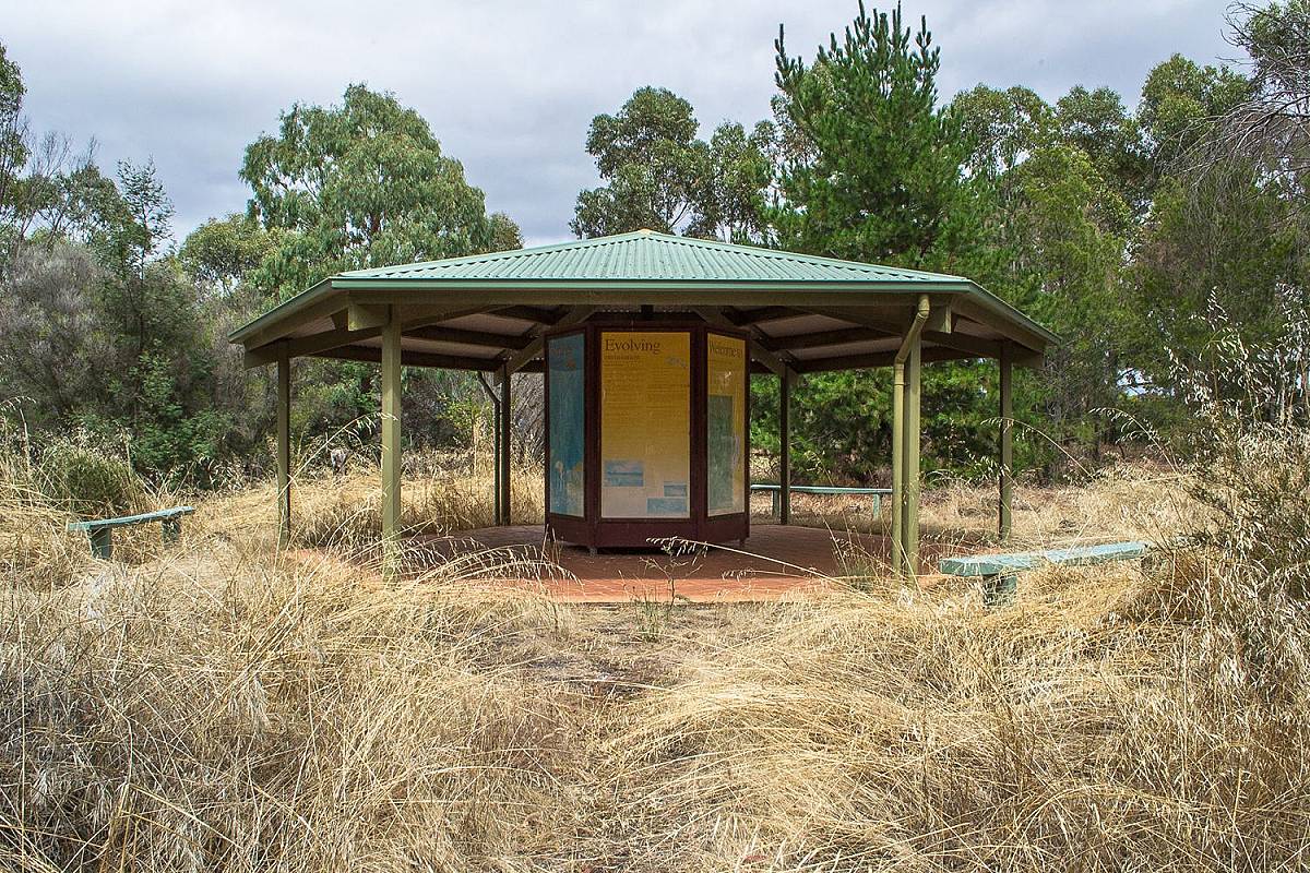
Another walking track takes you from the brick ruins over to a gazebo which houses a series of informative display signs, providing insights into the area's aboriginal history, pioneer history, gold mining history, geology and wetlands.
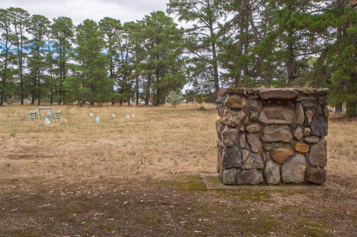
Continuing beyond the gazebo will take you to a large clear area with a picnic table, and beyond this in the far right corner you will find a stone wall and gate which was built in 1999 by the Green Corp Group.
Chalks No. 3 gold mine opened on this site in 1887, and a total of 32,156 ozs of gold was recovered from the deep lead (ancient buried river bed) on which it was working. The main shaft was sunk in 1888 to 280 feet, water pumping commenced in 1892 and continued pumping until 1900. Throughout most of this time, two million gallons of water were pumped per day. In 1895, Chalks combined with Stewarts.
-
Plantings of typical woodlot trees
- Plantings of those special plants, shrubs and trees which are so attractive to our native birds, together with a permanent water hole which adds to the attraction and enjoyment of the birds.
- A diversity of plantings which illustrate the many native plants of the region.
- Small wetland areas at the rear of the park provide a natural habitat for birds, animals, insects and plants.
- Walking tracks through the old pine forests. Those exotic trees will be progressively replaced by native vegetation.
- An area of native grassland.
- The site of a major gold mine ...Chalks No. 3
- The remains of huge mullock heaps and the plantings which will progressively be made in the unnatural soil.
- the Heritage Walkway with reminders of the enterprises our pioneers created as they built our social heritage.
Gold of the region
GOLD MINING
The discovery of gold throughout this region in the 1850's created great excitement and enormous population movements.
- The population of the Maryborough mining district rose from a few hundred to over 25,000 people in less than six months.
- Miners travelled from all parts of the world. Chinese were the largest group numbering up to 4,600 in the area. In order to avoid a Victorian tax, many Chinese travelled by ship to Guichen Bay South Australia and walked or rode overland to the gold fields.
- Living conditions were temporary and poor for the itinerant goldseekers.
- Transporting of gold was hazardous, bushranging came into existence, gold was packed in iron boxes and transported to Melbourne, initially by coach, later by rail.
- The geology of the region indicated that gold would be found in both the shallow and deep streams and leads, initially gold was found on the surface and in comparatively shallow workings.
- Mechanisation in many forms sped the process of extracting the alluvial gold, these are two examples of simple machinery used by the miners. See figures A and B (note: these are images of a whim and windlass, used to lift material out of a mine shaft).
As the supply of gold reduced and the shafts became deeper the mining changed. Attention was also given to the deeper leads and deep mining operations in the area commenced. Details are given in "Maryborough; A social History" (Chapter 11) by Betty Osborn & Trenear DuBourg. See figure C (note: this is an image of underground gold mine).
A Diamond Drill Report of 1887 comments
"the sub-basaltic western tributary which commences near Mt Beckworth passes to the east of Evansford and continues on in a northeasterly course passed Mt. Greenock, Talbot, Majorca and Carisbrook and finally joins the main lead in the parish of Baringhup....on the northern end of this large tributary between Carisbrook and Baringhup three mines are now at work, viz the Chalks No, 3, New Havillah, and Charlotte Plains Consolidated."
Many bores were sunk to determine the size and direction of the leads and the preferred location for the shafts to be sunk.
- In 1887 the Chalks No. 3 Mine opened on the site. In 1888 they began the main shaft which was sunk to 280 feet. They commenced pumping water on 10th October 1892 and pumped till November 1900 pumping two million gallons of water per day most of that time. Chalks Combined with Stewarts in 1895.
- A total of 32,156 ozs of gold was recovered from this mine. See figure D, E and F (note: images of mine and miners).
- Tons of material from the mines was stockpiled on site and over the years much was removed to be used for roadworks, some was transported to Mildura for use in Dam construction.
- The residues from mining are evident in the mullock heaps on the roadsides and in the area where diggings are still evident, conservation efforts are still required to replant and develop natural growth. See figure G, H and I (note: images of local mine sites as they appear today).
- Much information is available on the history of gold mining. Newspapers of the day carried details which have been researched and published, the Historical societies in Carisbrook and Maryborough are places to investigate the fascinating stories of Gold, as are the excellent books by local authors.
ABORIGINES OF THE AREA
The Wurn Balug Clan
For at least 30,000 years the aboriginal tribes inhabited the Australian continent undisturbed. Despite the lack of most cultivated crops and domesticated animals, the aboriginals used their knowledge of their land and their accumulated skills to live while conserving what resources were present. They regarded themselves as a part of nature and lived within the natural limits of the land. They possessed a deep sense of identity with their ancestral land which provided the central meaning in their lives, they enjoyed a spiritually rich culture with few material possessions.
Before the arrival of white settlers, the Kulin tribe extended from Melbourne through Central Victoria and shared common religious and social affiliations. The Kulin were divided into two moieties (halves) known as bunjil (eaglehawk) and waa (crow).
The Dja Dja Wurrung language group was part of the Kulin, (population was unknown but estimates did put the number between 900 & 1800 persons in 1841), and was composed of 16 clans, whose estates encompassed the land extending from the northern slopes of the Great Dividing Range, near present day Kyneton, to Amphitheatre.
Each clan was a member of one of the two moieties; moiety affiliation determined marriage and social relationships with other individuals. Women married outside their clan group into the opposite moiety; descent and residence was patrilineal.
The Wurn balug (clan) were of the Bunjil moiety of the Dja Dja Wurrung language group, their estate is reported to have included the lands between Carisbrook and Daisy Hill.
The Wurn balug were amongst the Dja dja wurrung clans who were invited to Melbourne by the Woiworung clans for large ceremonial gatherings near the junction of Mern Creek and the Yarra River (Clark 1990:166). It is possible that they shared reciprocal arrangements with some of the Woiworrung clans for visits to their own clan estates.
Both the Wurn balug and the neighbouring Gunangara balug at Mount Franklin (Lalgambook) appear to have borne the brunt of Duang wurrung attacks in the years before European settlement and contributed to the fact that so few individuals had survived by 1840. This also accounted for the extremely limited information about these clans.
The bark from mature native trees especially box and red gum, was removed by Aboriginal people to make canoes, huts, carrying containers, shields and shelters. The scars are more or less regular in shape, often with parallel sides and slightly pointed or rounded ends. These trees are important because they tell where Aboriginal people lived and enable us to find other Archaeological information. These wooden items were all found in this district and reflect their skills and craftsmanship and ingenuity.
There also appear to have been attacks by Europeans on Aboriginal people in the area which would also have contributed to the decline of the Wurn balug population. Venereal disease also contributed to high death and infant mortality rates amongst the Dja dja wurrung in the 1840s (Clark 1990: 1 5 0).
Several ceremonial gatherings involving Dja dja wurrung were observed near Mount Franklin, between 1843 and the 1860s.
By 1840 the remaining members of the clan were Wilkarmin who was the last clan head, and Yerre bulluk, his woman Malingorook and three female children. Wilkarmin died in 1859.
Yerre bulluk became the head of two Aboriginal families who held a farm of 21 acres at Franklinford during the 1850s (Clark 1990: 167, Rhodes 1995: 42-43). After his death in 1862, his wife Eliza and daughter Ellen were moved to Coranderrk Station at Healesville.
Ellen, the last survivor of the clan, died at the age of 17 during 1866.
The sign also includes displays about wetlands, geology, and the evolving environment of the area.